
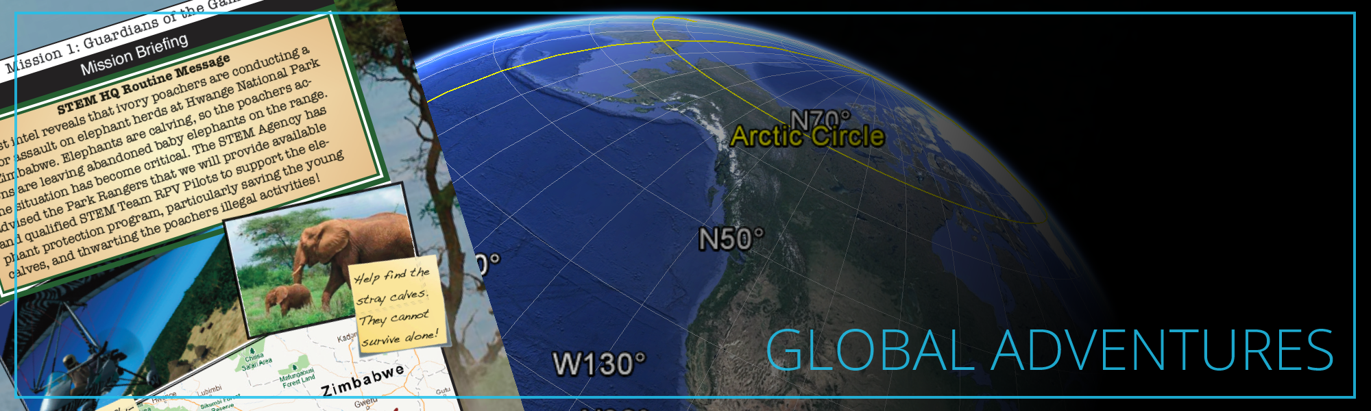
Mission One: Guardians of the Game
Latest intel reveals that ivory poachers are conducting a major assault on elephant herds at Hwange National Park in Zimbabwe. This Flight Team RPV mission is to provide air search support for the Park Rangers as they locate and transport the baby elephants to safety. Students will:
- Demonstrate accurate heading, airspeed and time management skills to optimize search (dead reckoning).
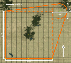
- Plot search pattern and apply mathematics to determine the search area size and leg lengths.
- Calculate time and fuel requirements to determine allowable time airborne.
- Using internet resources, determine pertinent facts about the Hwange National Park.
- Recall the basic operation of Personal Locator Beacons (PLB).
 Mission Two: Everglades Fire Fighting
Very dry conditions in the Florida Everglades have resulted in a wide outbreak of brush and forest fires, endangering wildlife and threatening inhabited areas at the edge of the Glade. The National Park Service and the Forestry Service have requested ACE Flight Team assistance and would like to use RPVs to drop cans of fire suppressing foam to fire fighters trying to extinguish fires before they get out of control. To accomplish this objectives, students must:
- Identify operating area characteristics including terrain features, elevation, habitats and climate data
- Recall various types and classes of fires
- Record and calculate time, speed and distance data to determine and plot fire locations on a map
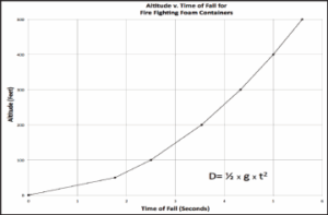
- Apply the physics of falling objects to accurately deliver firefighting material to fire locations
- -Use graph data to determine object time of fall versus altitude
- -Complete release distance data table for various altitudes and speeds
- Determine bearing and distance information from airfield to each plotted fire location
- Plan route from airfield to designated fire areas (Mission Part B)
- Convert operating area square mileage into acres
- Draft a “press release” describing operation and results
 Mission Three: Sitka Search
Major fluctuations in the Kuroshio Current are causing havoc with the North Pacific Ocean Gyre and the Alaska Current, resulting in extreme storm events along the Alaska coast. The U.S Coast Guard and Alaska Port Authorities requested ACE Flight Team HQ reconnaissance support to verify that aids to navigation (buoys) are in their correct locations.
Students must use precision piloting to fly directly over and GPS “tag” the actual location of the Sitka channel buoys. Exact locations are key to marine navigation. To do this, they will need to be able to:
- Determine geographic coordinates using a gridded (latitude/longitude) map
- Given an amount of fuel, calculate maximum flight duration
- Convert coordinates between degrees/minutes and decimal degrees
- Measure distances and directions on a map
- Recall and demonstrate proper use of a Visual Approach Slope Indicator (VASI)
 Mission Four: Maule in Nepal
Mount Everest is the highest point on earth. Getting there requires landing at one of the most dangerous airports on earth: Lukla Tenzing-Hillary Airport in Khumba, Nepal. In this remote region of the world, there is very little flat land upon which to build a runway. Therefore, engineers came up with a unique solution. They built a 1500 foot runway that instead of being nearly flat, has an incredible 12% slope! Pilots take off going downhill and land going uphill. However, this means that you can only land in one direction and must take off in the opposite direction. Also, with a large mountain at the end of the runway, pilots only get one chance to land. Preparation is the key to success in this extreme area.
Lukla Airport has experienced very bad weather for the past several weeks, cancelling nearly all flight operations. The Nepalese Police have requested ACE Flight Team assistance. Students will need to:
- Identify operating area characteristics including terrain features, elevation, habitats and climate data
- Compare and contrast “Best Angle of Climb” and “Best Rate of Climb” airspeeds
- Recall how altitude impacts aircraft performance
- Graphically represent runway slope as a percentage
- Plot Cartesian-type coordinates on a map
- Plot the route of flight on a map
- Create a vertical profile of the route of flight on a graph
- Convert between gallons and pounds of fuel to determine flight time duration
 Mission Five: Frisco Shakeup
A very high priority for RPV’s is emergency response for disaster relief and humanitarian purposes. The Federal Emergency Management Agency (FEMA) has heard great things about the ACE Flight Teams’ RPV capabilities. Therefore, they have asked that we evaluate the capability of RPV pilot teams to provide initial reconnaissance and logisitics support in rapid response to natural disasters. To do this, students should be able to:
- Determine geographic coordinates using a gridded (latitude/longitude) map
- Convert coordinates between degrees/minutes and decimal degrees
- Measure distances and directions on a map
- Calculate time and fuel requirements to determine allowable time airborne
- Demonstrate accurate heading, airspeed and time management skills
- Plot the route of flight on a map
- Recall the operating principles of Global Positioning System
- Apply Time-Speed-Distance calculations to determine arrival times
See below for an excerpt from Global Adventures mission 1.